Earliest Urban Civilization in the World.
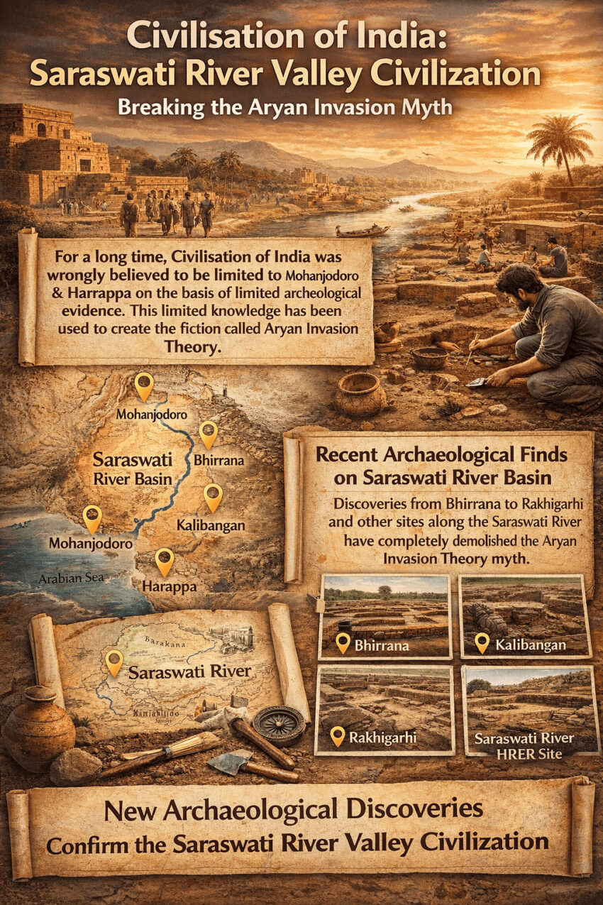
Civilisation of India is called Saraswati River Valley Civilization. Civilisation of India was wrongly believed to be limited to Mohanjodoro and Harrappa on the basis of limited archeological evidence. This limited knowledge has been used to create the fiction called Aryan Invasion Theory. The new archaeological finds have completely demolished this myth.
An obscure village called Bhirrana in tehsil Ratia, district Fatehabad, Haryana is not making the news it should. That silence is itself a story worth telling. The world is pretending blind.
Bhirrana is a site of immense historical importance. It offers a rare, continuous record of human settlement stretching from the pre-Harappan to the mature Harappan phase. For anyone interested in archaeology, it is a tangible link to one of the oldest civilizations on earth.
The debate is about who built Indian civilization, where it came from, and whether it was native or imported. The answer, as the ground itself now reveals, has been hiding in plain sight for decades.
Debunking Aryan Invasion Myth
Bhirrana is not an isolated discovery. It is one node in a vast, interconnected network of ancient settlements that archaeologists have been mapping across the Saraswati and Indus river systems for over a century.
K.N. Dikshit, former Joint Director General of the Archaeological Survey of India, has spent decades synthesizing this data. His 2022 paper in the Abhidha Journal of Art, Archaeology and Cultural Heritage presents the most comprehensive picture available. The evidence spans sites across Pakistan and India: Mehrgarh, Jalilpur, Harappa, Kot Diji, Rehman Dheri, Gumla, Kunal, Bhirrana, Girawad, Farmana, Rakhigarhi, Baror, Kalibangan, Banawali, Balu, and dozens more.
Every site has same story. People settled here. They built, evolved, and grew more sophisticated over thousands of years. There is no sudden rupture. There is no cultural gap. There is no moment where a foreign hand reached in and installed a new civilization. This contradicts the fiction of Arayn Invasion Theory. More about this myth after we discuss the evidence which demolishes this myth.
The Saraswati River
The site of Bhirrana is on the bank of Ghaggar river. The ASI identifies the Ghaggar as the dried-up post-glacial course of the Vedic Saraswati river, described in the Rigveda as a great perennial river flowing from the Himalayas to the sea.
Western historians have dismissed this identification as religious mythology. Their dismissal has more to do with their narrative about propagating their favourite myth of Aryan Invasion Theory. Now, the geological record disagrees with that dismissal entirely.
The Ghaggar, Saraswati, Markanda, and Chautang rivers all rise from the Siwalik hills. Geologists including C.F. Oldham, D.N. Wadia, S.M. Ali, and V.M.K. Puri have studied the hydrographic history of this river system in detail. Their work shows clear evidence of dramatic changes in drainage patterns over millennia. The Giri river, which once drained into the Ghaggar, was deflected toward the Yamuna due to tectonic uplift. Several streams initially joining the Markanda near Nahan were similarly redirected.
The isotope data from the Ghaggar alluvium and the Thar Desert establishes a sub-Himalayan sediment source. This is the geological fingerprint of a snow-fed, perennial Himalayan river. The sediment which flowed from the mountains proves that a real, massive river once flowed here.
High-resolution satellite imagery from ISRO, published in 2006, shows the image of ancient dried-up channels running parallel to the Indus. A Dutch map from 1746, prepared during the Mughal period, depicts the Indus and the palaeo-Saraswati as parallel river systems. A British-period historical map shows the Saraswati, marked as ‘Sursooty,’ and the Ghaggar joining together and flowing parallel to the Indus before emptying into the Gulf of Kutch.
These are not mythological texts. These are satellite images, isotope analyses, and colonial-era cartographic records. The Saraswati was very real. Yet these are ignored to perpetuate the myth that India is a nation of migrants and not settlers. The web of lies created to justify Aryan Invasion Theory was a tacit attempt to justify British invasion and their brutal colonial rule over India.
The concentration of ancient settlements along dried-up river course makes the case even stronger. Major sites including Kalibangan, Banawali, Kunal, Rakhigarhi, and Bhirrana all cluster along the ancient Saraswati corridor. Civilizations always cluster along rivers. Barren lands do not support settlement.
Dikshit notes that the combined Saraswati-Ghaggar rivers were perennial in northern Rajasthan during both the Early Harappan and Harappan periods. Archaeological evidence of Painted Grey Ware sites appears in a narrowing bed, suggesting the river was gradually losing water supply. Rangmahal mounds appear in an even narrower bed. The drying of river was slow, documented, and traceable through the archaeological record itself.
Read on for details about technical stuff of archaeology.
Climate Record Corroborates
The archaeological sequence is supported by independent palynological data from lakes in Rajasthan, studied by Gurdeep Singh and others. This data outlines the climatic backdrop against which this civilization developed.
Before 8000 BCE, conditions were wind-borne and unsuitable for human settlement. Between 8000 and 7500 BCE, rainfall increased significantly. From around 7500 BCE to 3000 BCE, there was a slight but manageable decline in rainfall. This is precisely the window in which the earliest Bhirrana settlements appear in the radiocarbon record. This makes it the earliest human civilization or at least one of those.
The climate data and the archaeological data align. The civilization grew during a period of relative climatic stability, rooted in an environment that could support it. This is what indigenous organic development looks like. It contradicts the narrative that population of India arrived as invaders from a distant steppe.
Archaeological Finds
The most powerful evidence in the Dikshit paper is the sheer consistency of the developmental sequence across dozens of sites. The same story repeats everywhere, from the Gomal Plain in the northwest to North Gujarat in the south.
The Earliest Settlers
At the lowest levels of sites like Kunal, Bhirrana, Girawad, and Farmana, archaeologists find circular or oblong subterranean pit dwellings cut into the natural soil. These pits are typically about two meters in diameter and just over a meter deep. They have rammed floors, smoothened walls, and post-holes around their edges, suggesting huts were built above them.
The people living in these pits were not primitive wanderers. They used copper fish hooks, bone tools, microbeads, arrowheads, and a distinctive pottery tradition called Hakra Ware. This pottery, decorated with mud appliqué designs and incised patterns, appears consistently across a wide geography. It links the earliest settlers of the Saraswati valley to a shared cultural tradition.
At Kunal, the dwelling pits also yielded gold and silver ornaments stored in a globular pot. These were not subsistence-level refugees. They were a people with craft skills, aesthetic sensibility, and accumulated wealth. They were settled at home.
The Transition to Urban Life
Over centuries, without any break, the pit dwellers move above ground. They begin building rectangular mud-brick houses. The bricks are standardized, often in a 1:2:3 or 1:2:4 ratio. This standardization requires shared knowledge, coordinated effort, and a functioning social structure.
Archaeologists classify the occupational sequence at these sites into periods. Period IA is the earliest, the pit-dwelling Hakra Ware phase. Period IB marks the transition to above-ground mud-brick construction. Period IC is the proto-urban transitional phase. Period IIA and IIB represent the Early and Mature Harappan phases respectively. This classification, used consistently across sites by the ASI, allows direct comparison between Kunal, Bhirrana, Kalibangan, and dozens of other sites.
At Kunal, period IB shows dwelling pits lined with finely molded mud bricks conforming to standard Early Harappan sizes, with well-designed hearths. By period IC, rectangular houses appear at ground level with drainage systems and soakage jars fixed in street pits. The transition from pit to house is not sudden. It is gradual, continuous, and entirely internal.
At Girawad, while pit dwellings continued, the same people simultaneously began building permanent mud-brick structures at ground level. The site shows elements from the Amri, Kot Diji, and Hakra traditions all present in the lowest Early Harappan levels. Pottery kilns dominated the area. This was not a settlement of refugees. It was a manufacturing and trading community in active development.
At Farmana, excavations beginning in 2006 revealed the same pattern: pit dwellings at the lowest levels, gradually transforming into above-ground rectangular mud-brick structures, followed by full Mature Harappan remains with the same ceramic continuity.
The Fortified City Phase
At Bhirrana, the full sequence is visible in a single site. The earliest inhabitants lived in subterranean pits using Hakra Ware ceramics along with mud appliqué pottery and incised ware. The other material remains include disc beads of steatite, terracotta bangles, and crucible fragments with molten copper. These are the traces of a functioning artisan economy.
From these modest beginnings, the settlement evolved into mud-brick structures using the standard 1:2:3 ratio of the Early Harappan period. Then came the fortification. A massive mud-brick wall, ninety-five meters in length, five meters wide, with seventeen courses rising to a height of 1.80 meters with a plaster coating on its external face, was built around the settlement. This is urban infrastructure. This takes detailed planning, labor organization, and civic authority.
By the final phase, Bhirrana was producing the iconic steatite (soapstone) seals of the Mature Harappan civilization. Four such seals were found, depicting a three-headed animal, a bull, a unicorn, and a deer with a standing deity. One was carved from black steatite. A fragment of thick red ware bearing an incised figure of a dancing girl was also found, along with single hub wheels with spokes painted in black.
This was a city. Not a village. It is the earliest Urban Human Settlement in the world which was multi-functional, economically complex, planned, and fortified. No other excavation meets all these criteria at one place.
Harappa and the Wider Picture
At Harappa itself, recent work by Kenoyer revealed the Ravi and Kot Diji phases in the lowest levels. The earliest phase, period IA, features handmade ceramics in circular huts with constricted mouth storage pits. Hearths are lined with clay. Bricks are plastered with red ochre clay. Steatite beads and bead manufacturing waste appear alongside cartwheels.
Kenoyer notes that the standard Harappan brick size begins in the early Ravi phase, making clear that before the urban center grew here, the building tradition was already in motion. The Harappan phase follows without cultural gap, succeeded by Late Harappan and then Cemetery H. One civilization, one place, one unbroken line of development.
At Kalibangan, excavations in 1960-61 revealed a pre-Harappan deposit with three structural phases where brick sizes were significantly different from those of the mature Harappan. The site was a fortified settlement with a grid system of planning, fire altars, burials outside the settlement area, and an agricultural field dateable to around 2800 BCE with crisscross furrow marks. The pottery of this phase was widely prevalent across the Saraswati and Dhrisadwati valleys. Twelve radiocarbon dates from Kalibangan confirm the sequence.
Banawali is located on the right bank of the Saraswati in district Fatehabad, the same district as Bhirrana. Here the excavations revealed a continuous sequence running from Early Harappan through proto-Harappan, Mature Harappan, and post-Harappan periods.
In the earliest period, standardized sun-dried bricks are set in mud mortar with house walls oriented to the cardinal directions. The boundary wall was later built into a massive fortification wall. The Mature Harappan phase integrated the citadel and lower town with a standard wall, and the citadel occupied nearly half the entire area in a semi-ellipse. Finds include copper objects, beads of carnelian, lapis lazuli, and gold, seals, sealings, and weights.
At Balu, three phases of occupation show pre-Harappan ceramics in the lowest levels, followed by Mature Harappan pottery in phase B with a massive mud-brick platform, followed in phase C by late Harappan types with wedge-shaped mud-brick house drains. The same evolution, the same site, the same people.
The conclusion Dikshit draws from all of this is precise: the archaeological data from pre-Early Harappans to early Harappans shows a smooth transition without any break or cultural gap across Harappa, Jalilpur, and all excavated sites in the Hakra-Saraswati valley.
Age of Civilization?
The radiocarbon dating record is where the Dikshit paper becomes truly definitive. The Birbal Sahni Institute of Paleobotany in Lucknow conducted the C14 dating for both Bhirrana and Rakhigarhi. This is not a Western institution making claims from a distance. This is Indian science, from Indian soil, processed in India.
Bhirrana: The Oldest Known Site
The C14 table from Bhirrana in the Dikshit paper lists eighteen sample dates. This is not two charcoal samples as alleged by some western critique on Wikipedia. This is a comprehensive, multi-level dataset spanning the entire occupational sequence of the site. The oldest date, sample BRN 9, gives a calibrated age of 7570 to 7180 BCE. Sample BRN 6 gives a calibrated range of 6689 to 6201 BCE. The bracket for the earliest occupation is therefore between 7570 and 6201 BCE.
Dikshit categorizes the full sequence as follows. The earliest period, roughly 7500 to 6000 BCE, corresponds to the Neolithic phase with subterranean dwelling pits. The transitional period, roughly 6000 to 4500 BCE, shows the shift from pit dwelling to ground-level construction. The Early Harappan phase runs from around 4500 to 3000 BCE. The Mature Harappan from around 3000 to 1800 BCE. The Late Harappan continues until around 1600 BCE.
This timeline places the roots of the civilization at Bhirrana firmly in the seventh to eighth millennium BCE. That is not a regional footnote. That places this civilization among the oldest known continuous urban traditions anywhere on earth.
Mehrgarh: The Comparison Point
Mehrgarh in Balochistan was previously considered the oldest site in the Indus-Saraswati cultural zone. The French Archaeological Mission excavated it between 1974 and 1985 and established continuous cultural development since the seventh millennium BCE. The earliest radiocarbon date from Mehrgarh period IA is 7435 BCE.
Bhirrana, at 7570 BCE, is older.
Mehrgarh remains an extraordinary site. Its ten meters of mound build-up from 6500 to 5500 BCE, and the continuous occupation from the end of the eighth millennium to the middle of the third millennium BCE, make it one of the great archaeological records of the ancient world. But the claim that it was the cradle of the Indus-Saraswati civilization must now be revised. The cradle is on the Saraswati, in Haryana.
Rakhigarhi: Corroborating the Record
The Rakhigarhi radiocarbon dates from the Birbal Sahni Institute provide twelve samples. The earliest calibrated date from this site is 6180 BCE. The dates span from the Early Harappan through the Mature Harappan phases, with all three structural phases of period I showing drainage systems, courtyard floors, circular pits, and fire chambers. The site confirms the same developmental arc visible at Bhirrana, Kunal, and Girawad.
The DNA from Rakhigarhi
The radiocarbon and archaeological evidence is compelling. The DNA evidence is conclusive.
Prof. Vasant Shinde and Dr. Neeraj Rai of the DNA Laboratory of the Centre for Cellular and Molecular Biology in Hyderabad carefully cleaned skeletal remains from Rakhigarhi, selected samples from the petrous bone, and prepared two libraries from each sample. Dr. Rai analyzed and sequenced the first set in India. The second set was provided to Dr. David Reich at Harvard Medical School for independent sequencing, analysis, and cross-checking.
The DNA signature in the Harappan human bones was weak. Dr. Reich carried out hundreds of tests before obtaining reliable signatures from a few skeletal remains. What those signatures showed was unambiguous.
In the words of Prof. Shinde, as quoted in the Dikshit paper: the ancient DNA results completely reject the theory of Steppe pastoral or ancient Iranian farmers as a source of ancestry to the Harappan population. The South Asians began domestication and independently introduced a settled way of life in this region. The same people developed Harappan culture and civilization. This is amply evident in the archaeological data from Mehrgarh. The ancestry of the Harappans is South Asian and indigenous. Neither Iranian farmers nor Steppe pastoralists have any role in the formation of the ancestry of South Asians.
This statement comes from a peer-reviewed, collaborative study involving both Indian and Harvard scientists. It is not speculation. It is not nationalist assertion. It is the outcome of a rigorous laboratory process applied to actual human remains from the actual site.
DNA does not negotiate with colonial narratives. The Harappan people were local. They were already here. They built this civilization from within.
The Civilization Extends to North Gujarat
The Saraswati valley is the heartland, but the civilization’s reach was wider. In North Gujarat, recent excavations have revealed an important early chalcolithic tradition called the Anarta pottery tradition, linking this coastal region to the same cultural complex.
At Loteshwar, excavations revealed a habitational deposit with circular pits varying from 0.50 to 2.00 meters in diameter, filled with ash, pottery, animal skeletal remains, steatite micro-beads, shell, semi-precious beads, and terracotta objects with reed impressions. Radiocarbon dates from this deposit fall between 3600 and 3000 BCE. Below this, a substantial mesolithic occupation dates to around 4700 BCE, with newer AMS dates pushing the beginning of the Mesolithic at the site to 7000 BCE.
The Anarta pottery tradition appears not only at Loteshwar but also at Baror, Bhirrana, Girawad, and in the Ravi phase pottery at Harappa. This confirms that the pre-urban Harappan societies of the Indus and Ghaggar-Saraswati basins shared common cultural traits across a vast geography. The network was real, active, and internally connected.
As Dikshit notes, the Harappan proliferation was bigger in area than Egypt and Mesopotamia. It was the largest ancient civilization by geographical extent. And it grew from within, not from outside.
Aryan Invasion Theory
The Aryan Invasion Theory was propounded by Max Muller in the nineteenth century. It proposed that Indo-Aryan tribes from Central Asia invaded the Indian subcontinent around 1500 BCE and brought with them the Vedas, Sanskrit, and the foundations of Hindu civilization. There was no archaeological proof for this claim when it was made. The excavations that would prove it to be false had not yet been done.
The Jaipur Dialogue in 2019 offered prize money to anyone who could demonstrate the Aryan Invasion Theory using archaeological evidence. Nobody claimed it. The prize remains unclaimed because the evidence does not exist. What does exist is an unbroken archaeological record of indigenous development stretching from the eighth millennium BCE to the decline of the Mature Harappan phase. All this confirmed by radiocarbon dating, corroborated by ancient DNA, and supported by satellite imagery and isotope analysis.
The theory survives not on evidence but on institutional momentum. Western academia built an entire apparatus around this idea. Textbooks, peer-reviewed journals, and university curricula carry its assumptions forward through citation. A speculative claim is published in a prestigious journal. Other scholars cite that publication rather than the original evidence. Over time, the citation trail creates the appearance of established fact. Srikant Talageri has documented this process in detail with specific reference to the work of Michael Witzel.
The Western camp in this debate holds institutional prestige and publishing dominance. The Indian side holds the excavation data, the satellite imagery, the isotope analysis, the radiometric dating from the actual sites, and now the DNA from the actual bones. That asymmetry in narrative power does not make the Western critique more scientifically valid. It simply explains why the narrative persists despite the evidence against it.
The Colonial Manufacture of a Historical Narrative
The Aryan Invasion Theory did not emerge from disinterested scholarly inquiry. It emerged from a colonial context in which the intellectual framing of India served administrative and political purposes.
The Sanskrit Mill Operation, analyzed here in detail, refers to the industrial-scale translation operation run under the East India Company. Scholars like Max Muller, H.H. Wilson, and R.T.H. Griffith were credited with translating approximately 40,000 pages of dense Sanskrit text. The mathematics of this claim are impossible. They would have needed to produce nearly 1.5 finished, published pages every single day for nearly seventy consecutive years.
The actual translations appear to have been done by unnamed native scholars. British names were placed on the work. Those translations were then used as the evidentiary base for historical theories about India, including the theory that Sanskrit and the Vedas were brought in by invaders from outside. It was a closed loop: manufacture the translations, use the translations to build the theory, cite the theory as established scholarship.
H.H. Wilson’s Rig-Veda volumes continued to be published up to twenty-eight years after his death. Massive anachronistic errors appear in the translations, including New World crops such as roasted corn appearing in ancient texts. These are not the errors of a careful scholar working from primary sources. They are the errors of an assembly line operating under administrative pressure.
This matters not because it delegitimizes all Western scholarship on India, but because it explains why a theory with no archaeological backing became textbook consensus. The manufacturing of authority preceded the manufacturing of evidence.
The Evidence Speaks
Strip away the colonial narrative. Strip away the institutional prestige and the citation laundering. What does the actual evidence show?
It shows a civilization that began in the seventh to eighth millennium BCE in the Saraswati-Indus region. It grew from pit dwellers to mud-brick builders to urban planners in an unbroken sequence across dozens of sites. It produced standardized bricks, drainage systems, seals, weights, jewelry, and city walls. It traded across vast distances. It developed pottery traditions that spread from the Gomal Plain to the Saurashtra coast.
The DNA of its people is indigenous to South Asia. The river that sustained it was real, confirmed by satellite imagery, isotope analysis, and historical maps going back to the Mughal era. The radiocarbon dates place its origins before Mesopotamia, before dynastic Egypt, before any external population could plausibly have arrived to build it.
The Hakra-Saraswati valley laid a new foundation for urban life and set in motion the status of the Hakra-Saraswati region as the cradle of Indian civilization. All the pre-Early Harappan stages across northern Pakistan, Sindh, North Gujarat, Rajasthan, and Haryana point to the beginning of primary urbanization in the Indo-Pak subcontinent on lines of a developing trajectory comparable to Mesopotamian and Egyptian cultures.
The Saraswati River Valley Civilization did not arrive from outside. It grew here. From dwelling pits to steatite seals, from copper bangles to fortified cities, the entire arc of its development is visible in the ground, in the genes, and in the satellite images.
Bhirrana is not making the news it should, as it contradicts the colonial narrative. The oldest known roots of Indian civilization are indigenous, continuous, and deep. It is called Saraswati Valley Civilization.
Civilization of India predate any invasion by thousands of years. It was built by people whose descendants still live here. They also follow the traditions started in Saraswati Valley.
References and Sources:
- Primary Academic Source: K.N. Dikshit, ‘The Origin of Indian Civilization in Sarasvati Valley,’ Abhidha Journal of Art, Archaeology and Cultural Heritage, Vol. 2, No. 2, 2022, pp. 156-215. Dikshit is former Joint Director General, Archaeological Survey of India.
- Official Site: Ancient Site of Bhirrana, Haryana Tourism
- Jaipur Dialogue 2019 prize challenge to AIT: YouTube
- Sanskrit Mill Operation analysis:
- Selected bibliography from Dikshit 2022: Jarrige et al. (1995), Mehrgarh Field Reports. Kenoyer (2011), Harappa excavation reports. Shinde (2021), Rakhigarhi DNA findings. Rao et al. (2003-04), Bhirrana excavation. ISRO High-Resolution Satellite Imagery (2006). Mughal (1997), Ancient Cholistan.
- Citation Laundering in West. The method of intellectual lies.
- Selectively tailored article on Wikipedia: https://en.wikipedia.org/wiki/Bhirrana
- Recent excavation at Mohenjodaro: https://www.arabnews.com/node/2637253/pakistan